Andrew Borowiec's Projects

For forty years I’ve photographed the social landscape of the Rust Belt, America’s industrial heartland, which has been in steady decline since the 1980s. Houses have disintegrated, city blocks are boarded up, factories have been dismantled. People accustomed to a life of hard work have lost their jobs, their homes, and their place in the world. My photographs are, in part, about the specific identity of a place—its topography, its architecture, its history, the arrangement and decoration of back yards. I try to make pictures whose details serve as clues to understanding the values, aspirations, hopes, and dreams of the people who inhabit that landscape. The circumstances of the post-industrial Rust Belt reflect an increasing inequality found throughout Twenty-First Century America, where most people aren’t as well off as they used to be, or as they would like to be. At the same time, I want the pictures to also show signs of hope. The inhabitants of factory towns are tenacious and resilient. Though they may live next door to an abandoned factory out of economic necessity, they nonetheless struggle to achieve some semblance of the American Dream under less than ideal circumstances.
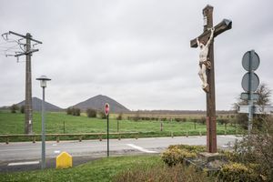
For almost four decades I've photographed America's industrial heartland gradually disintegrating into the landscape that we now call the Rust Belt. Sadly, that process was not unique to the US. The demise of industry had similar destructive results in other countries that were once in the forefront of the Industrial Revolution. A few years ago I began photographing former industrial regions in France. In 2019 and 2020 I made pictures in northern France's Basin Minier, in the departments of Pas-de-Calais and Nord, an area that was shaped economically, socially, and physically by intensive coal mining from the end of the 17th Century until the close of the 20th Century. In its heyday, the region was home to 885 coal mines in a 3,100-square mile area. The last mine closed in 1990, though a dozen or so headframes are still standing. Coal's most visible legacy is the approximately three hundred “terrils," man-made heaps of mining waste that punctuate the landscape like miniature volcanos. In 2022 I spent several weeks in northeastern France, in Lorraine, the former center of France’s steel industry. A map of the region published by the tourist office of the city of Thionville in 1919 identifies 140 separate sites related to iron and steel production, including dozens of sprawling steel mills that employed some 25,000 workers at their peak. While a few mills are still in operation, most were shut down and dismantled in the 1970s and 1980s. Like in the Basin Minier, what remains of of the region's industrial past are the "cités ouvrières," residential settlements built by industrial corporations, many of which are now slums for the unemployed descendants of factory workers. More recently, I made two extensive trips to photograph Belgium's "Sillon Industriel," the region in the southern region of Wallonia along the Sambre and Meuse Rivers that was once home to that country's iron and steel industry. In the 19th Century Belgium's steel industry was the second-largest in the world, exceeded only by Great Britain, and it brought considerable wealth to Belgium. However, those days of prosperity are long gone. In all three those regions, as in America's Rust Belt, the collapse of the economic base provided by manufacturing had devastating results: mass unemployment, social upheaval, and widespread deterioration of the built environment and landscape. I've tried to make photographs that not only describe those circumstances, but also give some sense of Europe's glorious industrial past.

I’ve photographed Wheeling, West Virginia, since the mid 1980s, when I first explored the Ohio River Valley. At the time Wheeling was a prosperous place that seemed stuck in a mid-Twentieth Century time warp, inhabited by legions of steelworkers who toiled in the giant mills that hugged the river banks and lit up the sky at night. Now, most of those plants have been shuttered and the jobs have disappeared. Beginning with the opening of the National Road in 1818, Wheeling served as an important conduit for trade and migration between the eastern United States and territories further west. Abundant timber, coal, and iron ore in the surrounding hills gave rise to widespread manufacturing including iron works, boatyards, glass factories, and tobacco plants. By1930 the town had become West Virginia’s commercial and industrial capital, with waves of immigrants from southern and eastern Europe swelling its population to over 61,000 inhabitants. Today fewer than half that number live in Wheeling. Its landscape of boarded-up stores, abandoned factories, and empty lots where buildings once stood is emblematic of the devastation that has swept through America’s manufacturing regions over the past twenty-five years. People who expected that a lifetime of hard work would earn them some semblance of the American Dream are instead losing their jobs, their homes, and their place in the world.

The Lincoln Highway opened in 1913 as the first road across America designed specifically for automobile travel. Originating in New York City’s Times Square, it traverses fourteen states to arrive at the edge of the Pacific Ocean in San Francisco. It constitutes a kind of cross-section of the country’s built environment and geographical terrain, passing through major urban centers, gritty factory towns, and virtually empty rural settlements; crossing mountain chains, dense forests, rich farmlands, and seemingly endless prairies and deserts. In an era when most goods were shipped by barge or railroad, the Lincoln Highway brought considerable prosperity to the hundreds of towns fortunate enough to be included on its trajectory from coast to coast. A century later, however, many of those communities exemplify the difficult times that Americans are facing in the lingering aftermath of the global economic crisis, even while some places along the Lincoln Highway have remained pockets of affluence. I began making these photographs in 2012, using the Lincoln Highway as a framework to examine the ideas that collectively define American identity such as the American Dream, Egalitarianism, belief in the sublime beauty of the Western landscape, the glorification of our agrarian past, nostalgia for small-town life, patriotism and military valor, ideals of feminine beauty, and other symbols and myths. Often the manifestation of those ideas sits in uneasy contrast with the ubiquitous evidence of commercial exploitation, economic hardship, industrial agriculture, and other complications. Without pressing the point, I think that part of what these pictures are about are the efforts we make to escape to a world constructed out of nostalgia, wishful thinking, historical revision, and fantasy.

These photographs investigate the social landscape of Ohio in the years 2004-2009. They illustrate the condition of a region that is widely perceived as representative of the American mainstream and they reflect ongoing changes in American values, cultural attitudes, and economic conditions in the first decade of the 21st Century. The rolling farmlands and idyllic small towns that used to define Middle-America are rapidly giving way to vast developments of mini-mansions and "lifestyle centers" designed to evoke an imagined era of luxurious consumerism, while traditional regional characteristics are becoming effaced by a ubiquitous global culture of global marketing. In the new heartland you can buy a quick fix of trendy espresso even out among the cornfields.

Please see the publisher's description of this project in my Books section.