
Seen in Otoe County (For this submission I’ve focused on 10 of images of water out of over 100))
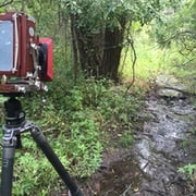
For three years I have been roaming the back roads of Otoe County, NE making images of the ways in which it is possible to interact with the land using a camera. Most of Otoe County like most of Nebraska is in private hands. There is little publicly accessible land. To photograph the land means that access is limited to what can be seen from the public right of way – the grid of roads that were laid out as the land was taken and occupied. Otoe County was one of the first counties settled after the Nebraska Territory was created in 1854. Before the Civil War, it had the territory’s largest population of enslaved people who were brought up the Missouri River to work the docks at Nebraska City. A treaty signed at Table Creek in 1857 dispossessed the Otoes and many other area tribes. None of that history could be deduced from looking at the land today. Today’s Otoe County is a farming area that produces primarily dryland corn and soybeans. Like many rural areas it has an aging population, farm consolidations and issues of water quantity and quality. The banks, seed companies and implement manufacturers dictate today’s farming methods as a condition of obtaining yearly operating loans. The young folks don’t stick. And many of the old folks sell out to neighbors but fear the inevitable rise of corporate agriculture. Most are very conservative and mistrustful of the government. It isn’t a very long way back to 1854 but the amount of change from then to now is enormous.
No categories selected
Photos (10)


